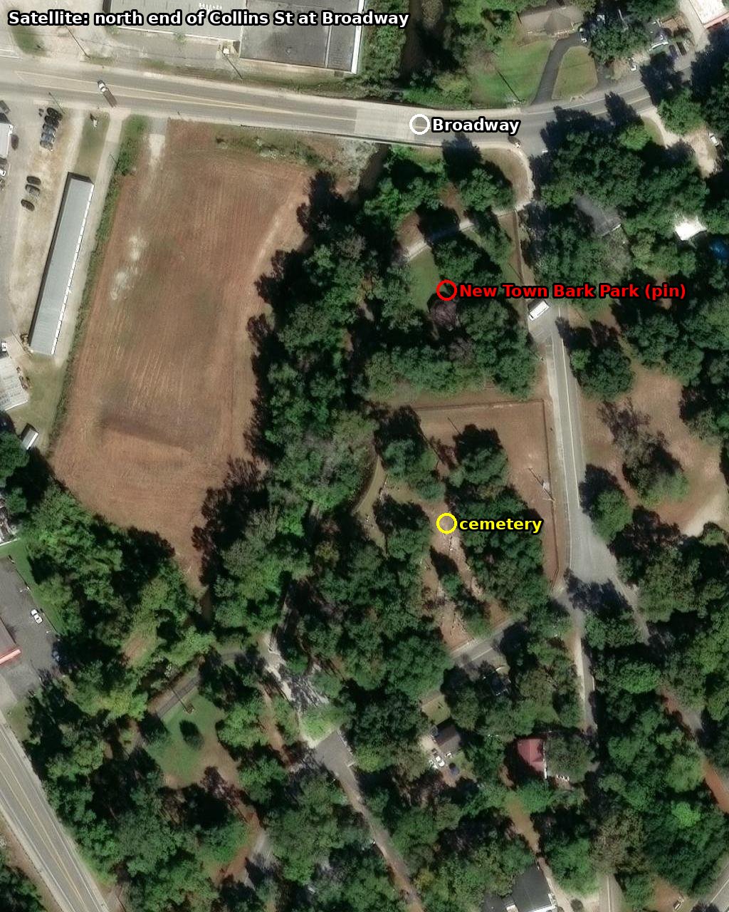
Verdict: New Town Bark Park, 200 Collins St — the city dog park at the north end of Collins St where it meets Broadway, west side, between a small cemetery and Withers Swash Park. Pin 33.6903, -78.8932. The rack stands on the grass just outside the dog-park fence; look for the inverted-U rack with the BikeWalkMB cut-out and read the number posted there.
Walk there (Google Maps) Back to the route
Walk there (Google Maps) Back to the route
In the plan it comes right after #5 Yellow & Blue (904 Chester St) and before #15 Blue E (210 3rd Ave S): 0.9 mi then 0.6 mi.
1. The clue photo
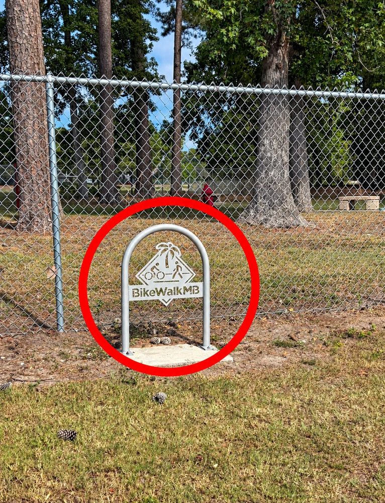
What is actually in the frame
- The rack is one of the City of Myrtle Beach's 50 BikeWalkMB racks (2017 grant program). The city put them at its own parks, beach accesses and buildings. That narrows it to city property.
- The fence is 6 ft chain-link, about twice the rack's height. Tennis and ball-court fences are 10–12 ft. Six feet is the standard dog-park fence.
- Inside the fence the ground is trodden bare in patches, there is a stone bench, and a red fire hydrant sits in the middle of the grass, well away from any road. Real hydrants stand at the kerb; a hydrant inside a fenced lawn is the classic dog-park prop.
- Behind that enclosure is a second, identical chain-link fence. Two adjoining pens = separate small-dog and large-dog areas.
- Trees: longleaf pines with big cones on the ground, plus a large hardwood. That rules out the open, treeless dog parks.
- No path. The rack sits on grass against the fence, not beside any pavement or trail surface.
2. The candidates
| Place | For | Against |
|---|---|---|
| New Town Bark Park, 200 Collins St (city dog park, opened Dec 2022) | City park (city racks). Two fenced pens. Reviews: “plenty of shade thanks to its many trees”, benches, hydrant-style props. Sits in the Withers Swash pine woods. 0.6 mi from #15 Blue E on the same leg of the course. | No street-level photo of the rack itself found online; the aerial below predates the 2022 build. |
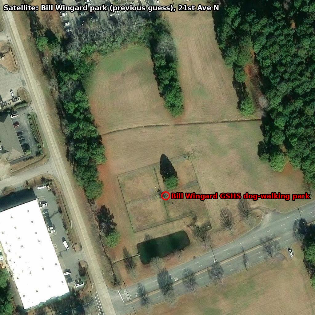
| Bill Wingard GSHS puppy playground, 21st Ave N at Mr Joe White Ave (our earlier guess) | It is a fenced dog area and the initials fit “B W”. | It belongs to the Humane Society shelter, not the city, so no city rack. The aerial shows a bare, open field with one small tree inside the pen and no pine stand. 2.1 mi off the course. |
| Barc Park South, Market Common | City dog park with pines. | That is already #9 Ruff Ruff (“Center S” = Barc Park South). Two checkpoints at one park is unlikely for a find-the-spot puzzle. |
| Barc Park North, 62nd Ave N at the YMCA | City dog park, tree cover. | Far north of everything else on the sheet; the organisers kept 2026 south of 48th Ave N. |
| A trail-side rack (Scott's theory) | City racks do stand at trailheads and beach accesses. | A trail rack sits on or beside the path; this one is on plain grass hard against a fence. The hydrant-in-a-lawn and the double fence are dog-park features, not trail features. And the nearest city trail system is the Withers Swash Park loop, which is the same block as New Town Bark Park, so the trail theory lands at the same corner. |
3. Where it is
4. On the ground
- From #5 Yellow & Blue go west to Broadway, follow Broadway south-west to Collins St, turn in. The park entrance and small car park are on the right, within about 100 m.
- Walk the outside of the fence line. The rack is at the fence with pines behind it; the hydrant and bench are inside the pen directly behind the rack.
- If there is nothing at the dog park, the Withers Swash Park loop starts across the lane. Check its trailhead before leaving the block.
- Enter the number posted at the spot in the app. Worth 2 points.
Sources: City of Myrtle Beach Bark Parks page (New Town Bark Park, 200 Collins St, opened Dec 2022, separate small/large dog areas); SC Energy Office success story on the BikeWalkMB rack program (50 racks, city locations); barkparkfinder and Yelp listings (“between a cemetery and Withers Swash Park”, “plenty of shade”, benches); WMBF (“3rd Ave S and Collins St” area); OpenStreetMap (Collins St meets Broadway at 33.6908, -78.8928; cemetery at 33.6896, -78.8932); Esri World Imagery.